|
Area of 103,000 sq km.
There are no bordering countries.
Cities – Reykjavík (capital) (capital, population 198 thousand), (2009 data)
Terrain: mostly plateau interspersed with mountain peaks; much of its area covered by glaciers; the coastline is deeply indented by bays and fjords, total coastline 4,970 km.
Very little arable land (just over 1%).
Mountains: the highest point is Hvannadalshnúkur (2,110 m at Europe's largest glacier, Vatnajökull).
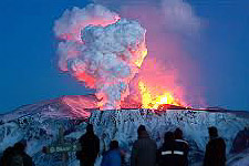
| Volcanoes: Iceland experiences severe volcanic activity; Grimsvoetn and Hekla are Iceland's most active volcanoes. Eyjafjallajökull (1,666 m) erupted in 2010, sending ash high into the atmosphere and seriously disrupting European air traffic; scientists continue to monitor nearby Katla (1,512 m) thought likely to erupt in the very near future, probably having a similar effect on air traffic. |
 |
Surtsey, one of the youngest islands in the world, rose above the ocean in a series of volcanic eruptions between November 1963 and June 1968.
Climate: Despite its name "Iceland" the North Atlantic current the Gulf Stream provides a temperate climate; with mild, windy winters but damp, cool summers.
Natural resources: fish, hydropower, geothermal power.
|
